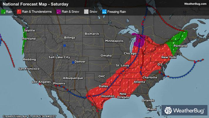
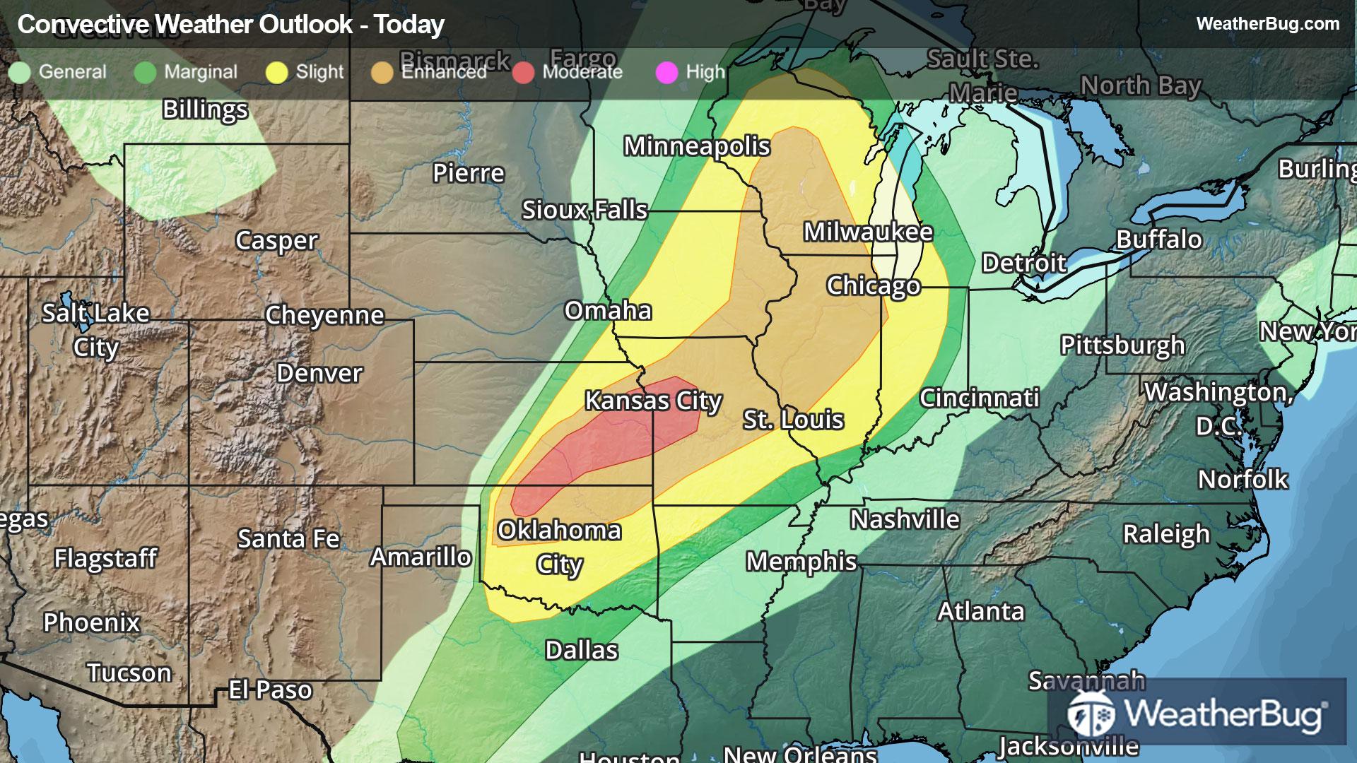
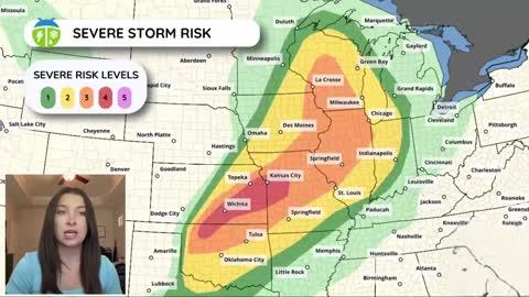
GroundTruthWeatherBug for Advertisers
  • Sign In
  • Press
  • Education
  • Feedback
  • Careers
  • Settings
  • Forecasts
  • Maps
  • Alerts
  • Life
  • News & Videos
  • Cameras
  • Air Quality
  • Hurricane
0
NowHourly10 Day
  • Today's Weather - San Antonio, TX

    May 16, 2025 11:25 PM
    San Antonio Intl Airport
    84°
    Weather forecast icon
    Feels like 91°
    Hi --
    Lo 78°F
    Warm and Humid
  • WEATHER DETAILSSan Antonio, TX
    • Windchill84°F
      Daily Rain0"
    • Dew Point74°F
      Monthly Rain0.40"
    • Humidity72%
      Avg. WindESE 15 mph
    • Pressure29.84"
      Wind Gust15 mph
    • Sunrise6:41 AM
      MoonWaning Gibbous
    • Sunset8:19 PM
      UV Index11 (Extreme)
  • WEATHER FORECASTSan Antonio, TX
    TonightLo 80°F
    Weather forecast icon
    Partly cloudy this evening then becoming mostly cloudy. Lows in the mid 70s. Southeast winds 10 to 15 mph. Highest heat index readings up to 107 early this evening.
    TomorrowHi 96°F
    Mostly cloudy in the morning then clearing. Highs in the upper 90s. South winds 10 to 15 mph with gusts up to 25 mph. Highest heat index readings up to 105.
  • Failed to load
    Something went wrong loading the data.
    Please reload the page or try again later.
  • Air QualitySan Antonio, TX
    46 | Moderate
    Top Triggers: PM2.5
    Air quality data provided by Ambee
  • POLLEN COUNT & ALLERGY FORECASTSan Antonio, TX
    ic_pollen_web
    7.5 Medium-High
    Predominant Pollen:
    Grass, Hickory/Pecan and Oak
  • Lightning MapSan Antonio, TX
    Closest strike in the last 30 minutes: 123.3 miles away
    No Lightning Nearby
    • TOP STORIES
      Big Storm Outbreak Peppers Middle Miss. Valley to Ohio Valley
      Dangerous thunderstorms will remain on the weather menu throughout tonight from the Ohio and Tennessee valleys to the Mid-Atlantic. Damaging wind gusts, large, destructive hail, and a few intense tornadoes will be possible.

      A large, potent storm system will lumber across Minnesota and the western Great Lakes through tonight. A cold front separating unseasonably warm, humid air from cooler and drier weather is attached to it. This same corridor will be peppered by repeated powerful thunderstorms overnight.

      Tornado Watches remain in effect across northern Arkansas and Tennessee, Kentucky and central and southern Indiana and southern Ohio into far western West Virginia. Memphis and Nashville, Tenn., Paducah and Louisville, Ky., and Indianapolis and Terre Haute, Ind., and Cincinatti and Huntingdon, W.Va. are included.

      A Severe Thunderstorm Watch is in effect from central to north-central and northeastern Texas, including the Dallas-Fort Worth metroplex and Waco. A Severe Thunderstorm Watch is in effect in eastern Ohio, West Virginia and far southwestern Pennsylvania. Youngstown and Canton, Ohio, and Wheeling and Charleston, W Va. are included.

      The government’s Storm Prediction Center has issued a Moderate Risk for a severe storm outbreak from far southeastern Missouri to much of Kentucky, and far northern and northwestern Tennessee to far southwestern Ohio. Louisville and Bowling Green, Ky., and Evansville, Ind., to Cincinnati, are included. An Enhanced Risk surrounds this zone from northeastern Arkansas to much of West Virginia, southwestern Virginia, and as far north as Interstate 70 from Illinois to Ohio.

      Isolated destructive wind gusts up to 80 mph, very large, damaging hail up to baseball size, and several tornadoes are likely. A few intense tornadoes will be possible, especially across the Lower Ohio Valley.

      Farther east in the Mid-Atlantic, isolated to scattered damaging wind gusts up to 70 mph and quarter to golf ball size hail will be possible. An isolated tornado cannot be ruled out either.

      So far today, there have been more than 75 severe weather reports dotting Arkansas and Missouri to Kentucky, West Virginia, southern New Jersey, and the Delmarva Peninsula. Golf ball size hail pelted Ned, Ky., with hail up to baseball size hail falling in Lost Creek, Ky., and Ava, Mo. A 63-mph thunderstorm gust was clocked near Merrimac, Va., with a gust to 60 mph measured near Wiley Ford, W. Va.

      Make sure to know the difference between a watch and a warning should they be issued. A “watch” means that conditions are favorable for severe weather to occur and to be on alert for any rapidly changing conditions. A “warning” means that severe weather is imminent, and you should act fast to remain safe.

      The best way to remain safe is to stay prepared and informed about your local weather. Have a severe weather kit packed with a battery-operated radio, water, and non-perishable food items. Also, check the WeatherBug app frequently for any updates on today's severe weather. Remember, "When Thunder Roars, Go Indoors!"
      Read More
      AEM Predicts Above-Normal 2025 Atlantic Hurricane Season
      Read More
      Weekend Weather Outlook
      Read More
      What Does A 'Moderate Risk' Mean?
      Read More
      Mix of Improvements, Degradations to Drought Depiction
      Read More
      Warmer Temperatures? Time For Heat Safety!
      Read More
      MORE NEWS
      • TODAY'S NATIONAL OUTLOOK
      • Hurricane TrackerSan Antonio, TX
        No Active Hurricanes or Warnings Issued
      • Allergy ForecastSan Antonio, TX
        • Cold & FluSan Antonio, TX
        • Snow & Ski ForecastSan Antonio, TX
    • Fire Updates
      San Antonio, TX
      Local Fire Map
    • Traffic Cameras
      San Antonio, TX
    • Weather Cameras
      San Antonio, TX
      No Weather Cams available in this region
    • Outdoor Sports GuideSan Antonio, TX
Always Have Access to WeatherBug at Your Fingertips, It's Free.
Connect With Us
© GroundTruth, 2025. WeatherBug is a brand of GroundTruth. All Rights Reserved. Terms | Privacy | Partners | Ad Choices | Sitemap | USA | FAQ | WeatherBug for Advertisers
  • North America
  • South America
  • Africa
  • Europe
  • Asia
  • Australia