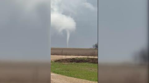
Sartell, MN Weather

As of

Weather Station:ST. CLOUD

Open weather station selector modal

19degrees Fahrenheit

Feels like:6°F

Hi: 19Lo: 15

70% Chance of Flurries

Live Weather Radar

Sartell, MN weather radar map

Current Weather Details

Windchill
Daily Rain
0"
Dew point
Monthly Rain
0.22"
Humidity
59%
Avg. Wind
S 14 mph
Pressure
30.05" →
Wind Gust
14 mph
Sunrise
7:38 AM
Moon
Waxing Gibbous
Sunset
5:23 PM
UV Index
2 (Low)

Weather Forecast

  • Tonight

    Lo

    Not as cold. Chance of snow late in the evening then snow after midnight. New snow accumulation of 1 to 2 inches. Lows around 15. South winds 10 to 15 mph. Chance of snow near 100 percent.

  • Tomorrow

    Hi

    Mostly cloudy. Snow likely in the morning then chance of snow in the afternoon. Snow accumulation up to 1 inch. Total snow accumulation 1 to 3 inches. Highs in the upper 20s. West winds 5 to 10 mph shifting to the northwest 10 to 15 mph in the afternoon. Chance of snow 70 percent.

Sartell, MN 10-day weather forecast

AIR QUALITY

19 | Excellent

Top Triggers:pm25
Air quality data provided by Ambee
View Today's Air Quality details for Sartell, MN

POLLEN COUNT & ALLERGY FORECAST

0.1 Low

Predominant Pollen:None
View the Pollen forecast details

LIGHTNING MAP

Closest strike in the last 30 minutes:1334.6 miles

No Lightning Nearby

Real-time lightning alerts & live Map