GroundTruthWeatherBug for Advertisers
  • Sign In
  • Press
  • Education
  • Feedback
  • Careers
  • Settings
  • Forecasts
  • Maps
  • Alerts
  • Life
  • News & Videos
  • Cameras
  • Air Quality
  • Hurricane
1
NowHourly10 Day
  • Today's Weather - Southaven, MS

    May 17, 2025 11:52 AM
    Sacred Heart School
    84°
    Weather forecast icon
    Feels like 85°
    Hi 86°F
    Lo 65°F
    Sunny
  • WEATHER DETAILSSouthaven, MS
    • Windchill84°F
      Daily Rain0"
    • Dew Point63°F
      Monthly Rain2.35"
    • Humidity49%
      Avg. WindWSW 2 mph
    • Pressure29.98"
      Wind Gust8 mph
    • Sunrise5:55 AM
      MoonWaning Gibbous
    • Sunset7:57 PM
      UV Index11 (Extreme)
  • WEATHER FORECASTSouthaven, MS
    TodayHi 86°F
    Weather forecast icon
    Sunny. Highs in the upper 80s. Southwest winds 5 to 10 mph.
    TonightLo 69°F
    Mostly cloudy. A slight chance of showers and thunderstorms in the evening then showers likely with a chance of thunderstorms after midnight. Lows in the upper 60s. Southeast winds around 5 mph. Chance of rain 60 percent.
  • Featured Videos
  • Air QualitySouthaven, MS
    35 | Fair
    Top Triggers: PM2.5
    Air quality data provided by Ambee
  • POLLEN COUNT & ALLERGY FORECASTSouthaven, MS
    ic_pollen_web
    4.9 Medium
    Predominant Pollen:
    Grass, Hickory/Pecan and Birch
  • Lightning MapSouthaven, MS
    Closest strike in the last 30 minutes: 177.5 miles away
    No Lightning Nearby
    • TOP STORIES
      Multiple Rounds of Severe Weather Targets Central U.S.
      Multiple rounds of severe weather will impact the central U.S. over the next few days.
       
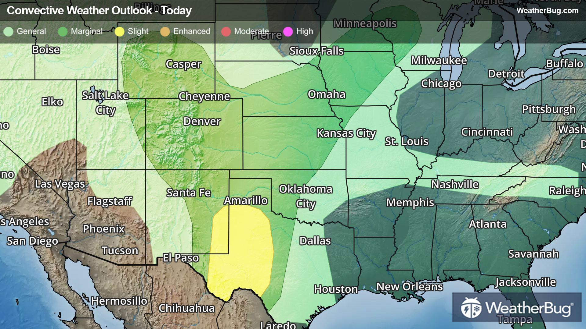
      Starting with today, plenty of hot, humid, and unstable air will be in place over the southern Plains. A nearly stalled front will separate this air mass from a slightly cooler and drier air mass farther to the north and west and will act as a focal point for thunderstorm development later this afternoon and evening.
       
      The result will be severe thunderstorms bringing threats for damaging wind gusts over 60 mph, very large hail, and even a few tornadoes.
       
      The government’s Storm Prediction Center has issued a Slight Risk, or a 2 out of 5 on the severe weather probability scale, across Texas into Arkansas, Oklahoma, and southern Kansas. An Enhanced Risk, or a 3 out of 5 on the severe weather probability scale, has been issued across portions of central and northern Texas.
       
      Some cities at risk today include Dallas, Oklahoma City, Little Rock, Ark., and Wichita, Kan.
       
      A few stronger thunderstorms will also be possible across the Deep South and Southeast today, including Jackson, Miss., Birmingham, Ala., Atlanta, and Charleston, S.C. 
       
      Strong to locally severe thunderstorms will also be possible today across the Northeast. The Storm Prediction Center has placed a Slight Risk across portions of northern New York, western Massachusetts, Vermont, and western New Hampshire. Damaging winds and large hail will be the primary threat, though an isolated tornado cannot be ruled out.
       
      Severe weather will continue Sunday across the Plains. The Storm Prediction Center has already issued a large Slight Risk stretching from northern Texas to Nebraska and western Missouri, including Dallas, Oklahoma City, Wichita, Kan., Kansas City, Mo, and Omaha, Neb. A smaller Enhanced Risk area is also found across parts of Oklahoma and Kansas. Sunday’s threats include very large hail, damaging winds, and a few tornadoes.
       
      Severe weather threats will persist on Monday across the central U.S. Slight and Enhanced Risks are already found from northern Texas to southern Iowa and western Illinois, including Dallas, Oklahoma City, Kansas City and St. Louis, Mo, and Des Moines, Iowa.
       
      Make sure to know the difference between a watch and a warning should they be issued. A “watch” means that conditions are favorable for severe weather to occur and to be on alert for any rapidly changing conditions. A “warning” means that severe weather is imminent, and you should act fast to remain safe.

      The best way to remain safe is to stay prepared and informed about your local weather. Have a severe weather kit packed with a battery-operated radio, water, and non-perishable food items. Also, check the WeatherBug app frequently for any updates on today's severe weather. Remember, "When Thunder Roars, Go Indoors!"
      Read More
      AEM Predicts Above-Normal 2025 Atlantic Hurricane Season
      Read More
      Weekend Weather Outlook
      Read More
      Mix of Improvements, Degradations to Drought Depiction
      Read More
      Understanding Severe Weather Hazards
      Read More
      Hailstone Measurement and Record Verification: How Is It Done?
      Read More
      MORE NEWS
      • TODAY'S NATIONAL OUTLOOK
      • Hurricane TrackerSouthaven, MS
        No Active Hurricanes or Warnings Issued
      • Allergy ForecastSouthaven, MS
        • Cold & FluSouthaven, MS
        • Snow & Ski ForecastSouthaven, MS
    • Fire Updates
      Southaven, MS
      Local Fire Map
    • Traffic Cameras
      Southaven, MS
    • Weather Cameras
      Southaven, MS
      No Weather Cams available in this region
    • Outdoor Sports GuideSouthaven, MS
Always Have Access to WeatherBug at Your Fingertips, It's Free.
Connect With Us
© GroundTruth, 2025. WeatherBug is a brand of GroundTruth. All Rights Reserved. Terms | Privacy | Partners | Ad Choices | Sitemap | USA | FAQ | WeatherBug for Advertisers
  • North America
  • South America
  • Africa
  • Europe
  • Asia
  • Australia