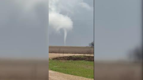
Thompson Falls, MT Weather

As of

Weather Station:ridge abv Lookout Pass 6000 ft elev

Open weather station selector modal

33degrees Fahrenheit

Feels like:39°F

Hi: 37Lo: 33

Partly Cloudy

Live Weather Radar

Thompson Falls, MT weather radar map

Current Weather Details

Windchill
--°
Daily Rain
0"
Dew point
23°
Monthly Rain
1.24"
Humidity
66%
Avg. Wind
-- mph
Pressure
30.1" →
Wind Gust
3 mph
Sunrise
7:35 AM
Moon
Waxing Crescent
Sunset
6:15 PM
UV Index
2 (Low)

Weather Forecast

  • Tonight

    Lo

    Partly cloudy until early morning then becoming mostly cloudy. Slight chance of rain late in the evening. Areas of rain and snow after midnight. Chance of precipitation 50 percent. Lows in the upper 20s to mid 30s. South winds to 15 mph after midnight.

  • Tomorrow

    Hi

    Rain likely and a chance of snow in the morning then rain and snow likely in the afternoon. Chance of precipitation near 100 percent. Snow level 4500 feet. Little or no new snow accumulation. Highs in the upper 30s to mid 40s. Southwest winds to 15 mph with gusts to around 30 mph.

Thompson Falls, MT 10-day weather forecast

AIR QUALITY

32 | Fair

Top Triggers:pm25
Air quality data provided by Ambee
View Today's Air Quality details for Thompson Falls, MT

POLLEN COUNT & ALLERGY FORECAST

0.4 Low

Predominant Pollen:Birch, Cedar/Juniper and Alder
View the Pollen forecast details

LIGHTNING MAP

Closest strike in the last 30 minutes:522.9 miles

No Lightning Nearby

Real-time lightning alerts & live Map