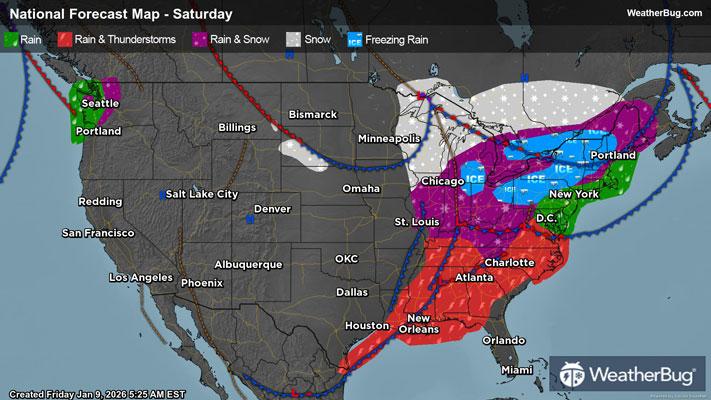
Flooding Rain, Gusty Thunderstorms Target the South
Flooding rain and gusty thunderstorms will move through the South today.
Read More
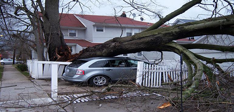
Flood Watch National Weather Service Birmingham AL 845 PM CST Fri Jan 9 2026 Marion-Lamar-Fayette-Winston-Walker-Blount-Etowah-Calhoun- Cherokee-Cleburne-Pickens-Tuscaloosa-Jefferson-Shelby-St. Clair- Talladega-Clay-Randolph-Sumter-Greene-Hale-Perry-Bibb-Chilton- Coosa-Tallapoosa-Chambers-Marengo-Dallas-Autauga-Elmore- Including the cities of Dadeville, Columbiana, Sylacauga, Clanton, Ashland, Double Springs, Moody, Hoover, Hamilton, Jasper, Fayette, Marion, Valley, Rockford, Centre, Lafayette, Selma, Heflin, Oneonta, Demopolis, Pelham, Wetumpka, Lanett, Greensboro, Talladega, Linden, Gadsden, Anniston, Tuscaloosa, Birmingham, Carrollton, Alabaster, Roanoke, Moundville, Pell City, Alexander City, Prattville, Livingston, Eutaw, Tallassee, Sulligent, Centreville, and Vernon 845 PM CST Fri Jan 9 2026 ...FLOOD WATCH REMAINS IN EFFECT THROUGH SATURDAY AFTERNOON... * WHAT...Flash flooding caused by excessive rainfall continues to be possible. * WHERE...A portion of central Alabama, including the following counties, Autauga, Bibb, Blount, Calhoun, Chambers, Cherokee, Chilton, Clay, Cleburne, Coosa, Dallas, Elmore, Etowah, Fayette, Greene, Hale, Jefferson, Lamar, Marengo, Marion, Perry, Pickens, Randolph, Shelby, St. Clair, Sumter, Talladega, Tallapoosa, Tuscaloosa, Walker and Winston. * WHEN...Through Saturday afternoon. * IMPACTS...Excessive runoff may result in flooding of rivers, creeks, streams, and other low-lying and flood-prone locations. Flooding may occur in poor drainage and urban areas. * ADDITIONAL DETAILS... - http://www.weather.gov/safety/flood PRECAUTIONARY/PREPAREDNESS ACTIONS... You should monitor later forecasts and be prepared to take action should Flash Flood Warnings be issued. &&
Closest strike: 14.61 miles Storms Approaching Stay alert and frequently check WeatherBug to see if storms are moving toward you. Be mindful that new storms can also form with little notice.
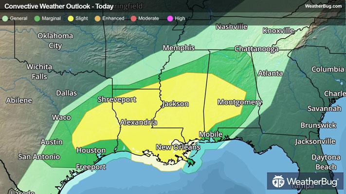
There is a Marginal Severe Storm Risk for your location. Continue reading for today's outlook from the National Weather Service's Storm Prediction Center. -------------------- National Severe Storm Outlook THERE IS A SLIGHT RISK OF SEVERE THUNDERSTORMS FROM EAST TEXAS TO CENTRAL ALABAMA SUMMARY Scattered severe thunderstorms are forecast across southeast Texas into the central Gulf states tonight. A few tornadoes and damaging wind gusts are possible. 01z Update Notable short-wave trough is beginning to eject northeast across the central Plains early this evening. Water vapor supports this with the center of circulation near DDC. 500mb speed max affiliated with this feature will strengthen and translate across north TX-southern MO-central IN by the end of the period. This evolution will result in negligible height changes along/near the Gulf coast overnight. As this feature advances east, LLJ is expected to increase across LA later this evening, strengthening into northern AL by 10/12z. Low-level warm advection has proven instrumental in convective development much of the day with scattered thunderstorms persisting across the lower MS Valley. However, some increase in convection appears to be occurring across east TX as the southern influence of the ejecting short wave glances this region. Earlier thoughts regarding severe potential remain. 00z sounding from LCH exhibits strong shear and ample buoyancy for supercells. Latest thinking is scattered-numerous showers/thunderstorms will persist along a corridor from northern LA into central MS with the potential for some uptick in intensity overnight as the LLJ strengthens.