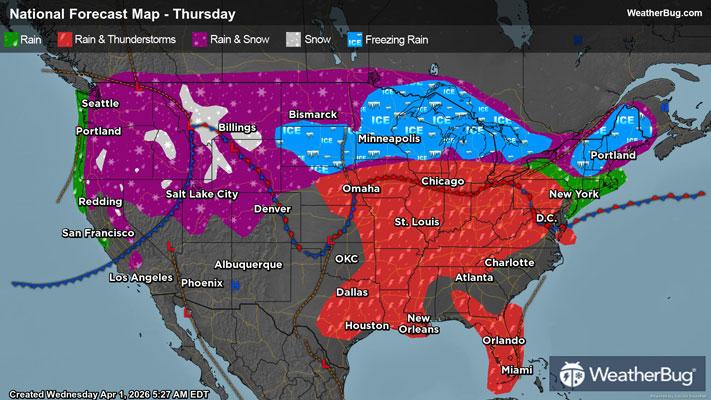
Heavy Snow Blankets the West through Upper Midwest

Two separate low pressure systems dragging moisture across the country bring snowfall to the West Coast through the Upper Midwest through the start of the weekend.
In the West, low pressure coming off the Pacific brings heavy snowfall to the Cascades beginning this evening and continuing until Thursday evening. These snowfall amounts will range between 9 and 14 inches, creating slippery road conditions over mountain passes.
The National Weather Service has issued Winter Storm Advisories and Winter Storm Warnings over the Cascades and into the northern Sierra Nevada from northern Washington down through northern California. Moderate to heavy snowfall will create low visibility conditions with gusty winds, prompting unsafe driving conditions.
In the Sierra Nevada, snow accumulation is expected to range slightly lower than that of the Cascades, ranging between 6 and 12 inches of snow. Periods of moderate to heavy snowfall are still possible with gusty winds, creating equally dangerous driving conditions over the mountain range.
As this moisture moves eastward, Winter Storm Watches, Winter Storm Advisories and Winter Storm Warnings have also been issued over the Rockies, encompassing the areas surrounding the Denver metro and much of western Montana. Snow should begin accumulating as early as Thursday morning in these areas and are expected to continue through Friday.
The Rockies should expect some larger snow accumulation totals as well, with between 3 and 10 inches total near the Denver metro, and slightly lower accumulation amounts between 3 and 8 inches in the northern Rockies. Periods of moderate to heavy snowfall are possible at times, with wind gusts, and decreasing visibility and making mountain passes dangerous to drive through.
Meanwhile, a second low pressure system impacts the Midwest into Friday, bringing wintry precipitation. The eastern Dakotas into northern Minnesota can expect multiple rounds of wet snow or a mix of rain and snow. Freezing rain will also be a concern for southern Minnesota, much of Wisconsin, Michigan’s Upper Peninsula, and northern parts of Michigan’s Lower Peninsula.
The National Weather Service has issued Winter Storm Advisories from eastern North and South Dakota, extending through the Great Lakes. Within this region there are also scattered Winter Storm Watches, Winter Storm Warnings, and Ice Storm Warnings.
Ice accumulation that is possible within central Minnesota will be about 1/4 an inch accumulated, making surfaces slick, and possibly downing tree limbs or power lines. Accumulating sleet and possible freezing rain could occur during this storm. Ice storm impacts are expected Thursday morning, altering Thursday morning commutes, and possibly leaving some without power during the day.
Total snow accumulation upwards of 24 inches is expected along the Dakotas and Minnesota beginning tonight through Friday. Moderate to heavy snowfall with gusty winds can be expected in these areas, impacting this evening and Thursday morning commutes.
By Saturday, the low pressure system impacting the West during the week will move into the Midwest, allowing for additional snow and ice to accumulate and impact the Upper Midwest again. This snowfall and ice should continue within the area through the weekend, clearing up by Sunday afternoon.
In the event of possible impacted driving conditions, it is important to stay prepared and informed. You can better prepare yourself by having a winter weather kit packed with a battery-operated radio, water, non-perishable food items, and extra layers. Additionally, check the WeatherBug app frequently for any updates on upcoming winter weather.