Drought Worsens Nationwide Despite Multiple Disturbances
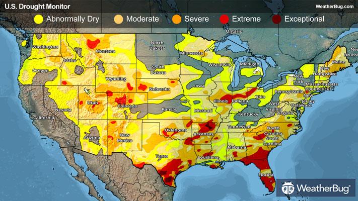
Despite there being several weather systems, precipitation throughout the U.S. was generally limited and not enough to make up both short- and long-term deficits that already exist. There were some localized improvements to the drought depiction this week, but most places saw worsening conditions or remained status quo.
Northeast
A couple fast-moving weather disturbances clipped southern portions of the Northeast over the past week. With these disturbances, there was a wide range of precipitation types, with rain, snow, sleet and freezing rain occurring at some point. However, this precipitation was not enough to make up for deficits adding up over the last 1 to 2 years. The northern portions of the Northeast also missed out on most precipitation and it has been largely dry.
As a result, drought coverage and intensity remained steady this past week for most of the Northeast. The one change that did occur was in southeastern New York, where moderate and severe drought (D1-D2) expanded.
Twelve and 24-month precipitation deficits are more than 8 and 16 inches, respectively, across portions of the Mid-Atlantic and New England. Severe to extreme drought (D2-D3) continues for parts of New England, northern New Jersey and eastern to southern Pennsylvania. The 28-day average streamflows remain low (below the 10th percentile) for much of the Northern Mid-Atlantic.
Southeast
Unlike the rest of the nation, the Southeast region experienced some improvements to abnormally dry and drought conditions over the past week. This was due to a stalled cold front draped over the region for much of the monitoring period, bringing rounds of moderate to even heavy rainfall. Rainfall amounts ranged from 1 to 3 inches with locally higher amounts, leading to 1-category improvements to parts of Alabama, Georgia and the Coastal Plain of the Carolinas.
Despite the locally heavy rainfall, only modest improvements were warranted for the Southeast as 90-day precipitation deficits exceed 6 inches across much of Alabama, Georgia and the Upstate of South Carolina. Most notably, severe to extreme drought (D3) contracted in eastern North Carolina, northeastern and west-central Georgia and east-central Alabama. Moderate to severe drought (D1-D2) decreased in coverage as well in eastern South Carolina.
Areas that missed out on this beneficial rain saw degradation to the drought depiction this week, which includes much of western Alabama, southern Georgia and southwestern Florida. Extreme drought (D3) worsened in southern Georgia and southwester Florida (just north of the Everglades), while moderate drought (D1) expanded in western Alabama.
Consistent with a La Nina winter, drought has worsened the past few months, with more than two-thirds of the Sunshine State designated with extreme drought (D3). According to the National Interagency Fire Center, a wildfire at Florida’s Big Cypress National Preserve has grown to over 35,000 acres burned at the beginning of March.
South
The same front stalled over the Southeast brought heavy rainfall to parts of northeastern Tennessee. Here, rainfall amounts added up to 1 to 3 inches, with locally higher amounts. This resulted in small 1-category improvements, where abnormally dry to severe drought lessened. Otherwise, the Lower Mississippi Valley and Southern Great Plains saw largely dry weather, with drought continuing to expand and intensify.
Exceptional drought (D4) worsened in southern Texas. Extreme drought (D3) was added to northwestern Louisiana, while extreme drought expanded in northwestern Mississippi, southwestern Arkansas, eastern Louisiana, southern Oklahoma and northeastern/ southern Texas. Severe drought (D2) worsened in northeastern Mississippi, much of Arkansas, southern/eastern Oklahoma and northern/eastern Texas. The rest of Mississippi saw abnormally dry and moderate drought (D0-D1) expand, with the state now fully seeing abnormal dryness and drought conditions. Moderate drought (D1) worsened as well in northern Oklahoma.
Since the beginning of December, precipitation has averaged less than 50 percent of normal across much of the Lower Mississippi Valley and Southern Great Plains. Impact reports from north-central Oklahoma include poor wheat conditions and surface water supply shortages.
Midwest
The Midwest saw a few clipper-type systems dart across the region during the first two-thirds of the drought monitoring period, then a more impactful system moved across the region in the last few days. There was a wide range of precipitation types with each system, ranging from rain and snow to freezing rain and sleet.
Despite precipitation occurring throughout the region, it was not enough to make up for mounting precipitation deficits. As a result, widespread degradation occurred to most of the Midwest region. This includes southern Minnesota, much of Iowa, northern Missouri, southeastern Wisconsin, northwestern Illinois, western/ eastern Indiana, western Kentucky and the eastern half of Ohio. Most notably, extreme drought (D3) expanded across west-central Indiana, while an area of severe drought (D2) was introduced in southeastern Iowa. The rest of the region saw abnormally dry and moderate drought (D0-D1) worsen.
There was a slight improvement in southeastern Missouri. Here, both moderate and severe drought (D1-D2) contracted.
Paducah, Ky., and Carbondale, Ill., had their driest meteorological winter (December 1 to February 28) on record.
High Plains
Although late winter is a relatively dry time of year across the Central Great Plains, periods of unseasonably warm temperatures and enhanced winds this past month led to intensifying drought across northeastern Colorado and Nebraska. While there was some wintry precipitation that fell over the last week, it was not sufficient to make improvements. In fact, the entire High Plains region saw abnormally dry and drought conditions worsen.
Degradation occurred to northern Wyoming, west-central/eastern Colorado, western/ central South Dakota, southern/eastern Nebraska and southern Kansas this week. Two areas of extreme drought (D3) were added to northeastern Nebraska and in the Front Range of Colorado near the Denver metro area. Moderate to severe drought (D1-D2) intensified in all other areas.
As of March 3, snow water equivalent is less than 70% of normal across the Central Rockies.
West
The Western U.S. did experience two weather systems over the past week, which brought rain and mountain snow to parts of the Northwest, Great Basin and northern Rockies. Like the rest of the U.S., this precipitation was just not enough to make up for precipitation deficits, especially given the drier and warmer than normal February.
Even areas that have received above normal precipitation since the beginning of October, snow water equivalent is running well below normal. The low snowpack throughout much of the West is a major concern heading into the spring. As of March 3, snow water equivalent is less than 50% of normal from the Cascades of the Pacific Northwest southward through the Great Basin and Four Corners region. Although California remains drought-free, snow water equivalent is 59% of normal statewide according to the California Department of Water Resources.
Drought degradation occurred in far southeastern Oregon, northern/southwestern Idaho, north-central Nevada, a large portion of Montana and eastern New Mexico. Most notably, a small area of extreme drought (D3) was introduced in southwestern Idaho, while severe drought (D2) worsened in southwestern/northern Idaho as well as southwestern Montana. All other areas saw abnormally dry and extreme drought (D0-D1) intensify this week.
Looking Ahead
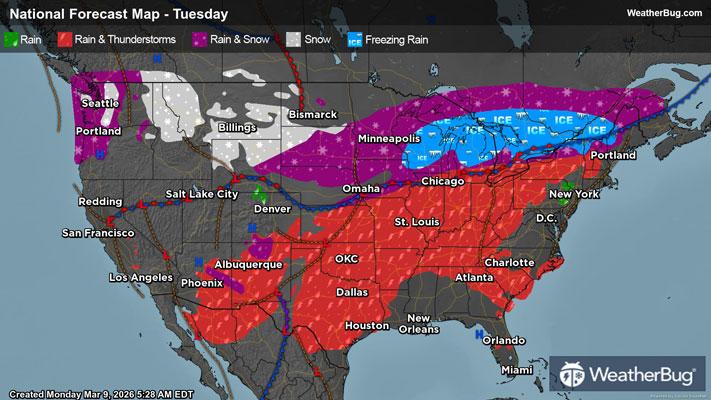
A significant weather pattern shift is expected for early to mid-March, bringing multiple low pressure systems across the Great Plains and Midwest. To start the drought monitoring period, the Weather Prediction Center forecasts a band of heavy precipitation stretching from south-central U.S. through the Lower and Middle Mississippi and Ohio valleys. This wetter pattern may extend into parts of the Northeast, while areas from Virginia southward to Florida are expected to see little or no precipitation.
Elsewhere, the Northern and Central Rockies are forecast to receive much needed snowfall. In contrast, California and the broader Southwest are likely to remain dry. At the same time, much of the southeastern and central United States is expected to experience well above normal temperatures, with the potential for daily record highs between March 5 and 9.
------
Source: U.S. Drought Monitor