Thursday's Weather Outlook
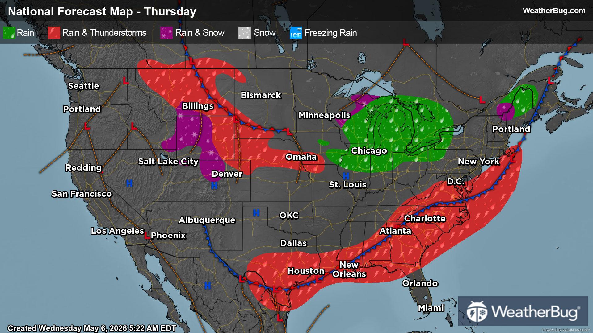
Much-needed rain will soak the Southeast while a cold front pushes through the Great Lakes and Northeast.
Strong storms from the day prior will set the stage for periods of moderate to heavy rainfall for the Southeast and southern Mid-Atlantic. Rain will be the heaviest in the morning before drying out for many before evening begins. Along the coast of the Carolinas, northern Florida, and western to central Gulf Coast, thunderstorms will be possible. Damaging wind gusts and localized flash flooding will be the main threats.
Early in the morning a few showers will exit out of the Northeast as a cold front begins to sweep through the area. In the afternoon, a couple light showers will move eastward out of the Great Lakes and into the western sections of the Northeast. Other than this activity, it will be mostly dry with overall chilly spring weather.
Associated with a lobe of cooler air out of Canada, showers will be likely for the Midwest and Ohio Valley. Rain totals are anticipated to be on the low side, and most will be dry.
A disturbance will slide southeastward through the northern to central Rockies of Montana, Wyoming, and Colorado. Rain showers are expected for the lowlands, while high terrain snowfall may stick to the peaks.
The rest of the Western U.S. will be dry besides the high terrain of the Sierra Nevada with a couple rain showers possible. Generally, dry weather will be found in the Great Basin, Desert Southwest, Pacific Northwest, Four Corners, and along the West Coast.
A few other dry spots will be found in the northern to central Plains and Mid-South where these areas will be in between disturbances.
The high terrain of the northern to central Rockies may feel 30s and 40s as well as parts of the Upper Midwest. Forties and 50s will be common for the Ohio Valley, northern Plains, and interior Northeast. While 50s and 60s will be felt in the coastal Northeast, Mid-Atlantic, Lower Midwest, and central to southern Appalachians.
Sixties and 70s are anticipated for the central to southern Plains, Mid-South, Deep South, Southeast, Pacific Northwest, Great Basin, Four Corners, and central to southern West Coast. Warmer 80s and 90s are expected in the California Central Valley, Desert Southwest, and much of the central to southern Florida.