Midweek Severe Storms Throttle U.S.
Powerful severe storms will charge through areas from the southern Plains to the Mid-Atlantic in the coming days.
The northern and southern U.S. borders will observe two separate and potent upper-air disturbances as they eject east of the Rockies today. The disturbances are set to influence each other and create an unstable weather pattern, and when combined with humid Gulf air surging into the Central U.S., ample severe thunderstorms are expected to arise today along strengthening warm and cold fronts. Supercells that form initially along and ahead of these fronts will eventually cluster up and form strong thunderstorm lines.
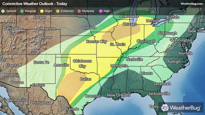
According to the Storm Prediction Center, two separate regions hold an Enhanced Risk (a 3 out of 5 on the severity scale) for severe weather today. The first area is posted from northeastern Missouri through northern Indiana, which holds a heightened risk for tornadoes thanks to increased upper-air energy in place. Cities beneath this region include Kirksville, Mo., Chicago and Peoria, Ill., and South Bend, Ind.
The second Enhanced Risk is posted across central Texas from the Rio Grande River to the Red River Basin, which holds a heightened risk for large and intense hail with plentiful moisture and instability at the surface. Cities that could be affected include Dallas, Fort Worth, Arlington, and Irving, Texas.
Both areas will likely see scattered reports of damaging winds. There is also a larger Slight Risk (a 2 out of 5 on the severity scale) encompassing and connecting these two greater risk regions from the Rio Grande River to Lake Ontario. Under the Slight Risk, isolated reports of large hail, damaging winds, and even a tornado or two are expected. Cities such as Detroit, Indianapolis, Oklahoma City, and Kansas City, Mo., are under this risk level.
By tonight, a new low pressure system will have formed from the two new disturbances, dragging up additional severe storms on Wednesday as its cold front sweeps eastward across the Deep South through the Great Lakes and Mid-Atlantic.
On Wednesday, the Storm Prediction Center has already issued a vast Slight Risk from eastern Texas through the Mid-Atlantic, with damaging winds, large hail, and a few tornadoes still in play along and ahead of the cold front. Additionally, the Ohio Valley and Lower Mississippi Basin are both expected to observe more concentrated and intense tornadic activity. Major urban areas such as Shreveport, La., Memphis, Tenn., Louisville, Ky., Pittsburgh, Philadelphia, Baltimore, and Washington, D.C. are included in the risk area.
Soaking rain, often in a short period, will be another impact to watch for underneath strong thunderstorms the next few days. Totals of 1 to 2 inches are likely for the Mid-South and Lower Great Lakes, with locally 2 to 3 inches or more possible in eastern Texas and southwestern Arkansas. This may lead to urban flooding, especially where poor drainage exists. If you approach a road covered in water, remember the old saying, “Turn Around, Don’t Drown!”
Make sure to know the difference between a watch and a warning should they be issued. A "watch" means that conditions are favorable for severe weather to occur, and to be on alert for any rapidly changing conditions. A "warning" means that severe weather is imminent, and you should act fast to remain safe.
The best way to remain safe is to stay prepared and informed about your local weather. Have a severe weather kit packed with a battery-operated radio, water, and non-perishable food items. Also, check the WeatherBug app frequently for any updates on today's severe weather. Remember, "When Thunder Roars, Go Indoors!"