New Year Storm Drenches California

Not a week after an atmospheric river’s deluge made the Los Angeles River mighty, rainfall returns to California to embrace the New Year!
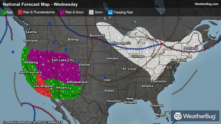
A low pressure area in the eastern Pacific Ocean is slowly chugging northeastward today, drawing up another surge of anomalously high water vapor content targeting California. Scattered light showers already grazed the southern coast this morning ahead of the storm, which are expected to intensify and spread both inland and northward through Thursday. Isolated to widely scattered thunderstorms will pair with the storm in southern California and the Central Valley overnight tonight, and sharp upper-level winds with these storms could enable damaging gusts and perhaps even a tornado threat along the southern coastline.
Despite the rain being lighter than last week’s event, soils are still not fully recovered from last week's rainfall, and it will not take much to trigger flooding. The best chance will be across southern California near burn scars, rivers, creeks, and streams, as well as urban, low-lying, and other more flood-prone areas. Those living in areas prone to flooding should also be prepared to take action should flooding develop.
Through New Year’s Day, rain accumulation will peak at 3 to 5 inches along both the Peninsular and Transverse Ranges, with 1.5 to 3.0 inches across their foothills as well as ahead of the Sierra Nevada Range. Rainfall of 1 to 2 inches will wash off along much of the southern and central Californian coasts, and rain less than an inch will rinse the Great Basin, the Desert Southwest, and much of the Mountain West.
Although mountainous snowfall will be limited under a warm air mass over the Western U.S., snowpack will thicken by up to 16 inches atop the peaks of the central Sierra Nevada Range through New Year’s Day. Snow amounts below a foot will drop across the Central Rockies’ ridges on Thursday as well, with the first moisture surge shifting inland.
So far, Flood Watches have been posted for the Transverse Ranges, the far southern Sierra Nevada Range, and the southern Californian coast from Santa Maria to San Clemente. Winter Storm Watches are in effect for most of the Sierra Nevada Range and part of the Klamath Range.
Following this first deluge, another low pressure system approaching the Pacific Northwest will corral the atmospheric river across the whole West Coast through this weekend. This time, however, heavy rain will focus on northern California.
Be sure to download the WeatherBug app to stay up to date on the latest on this changing weather. It’s never too early to have a supply kit packed in case of inclement weather. A simple kit including a weather radio, water, blankets, batteries, and non-perishable food items will go a long way in the event of a power outage.
