2026 Opens with Heavy Rain, Mountain Snow in the West
Significant rain and heavy mountain snow will continue to impact California and the rest of the West for the first few days of 2026.
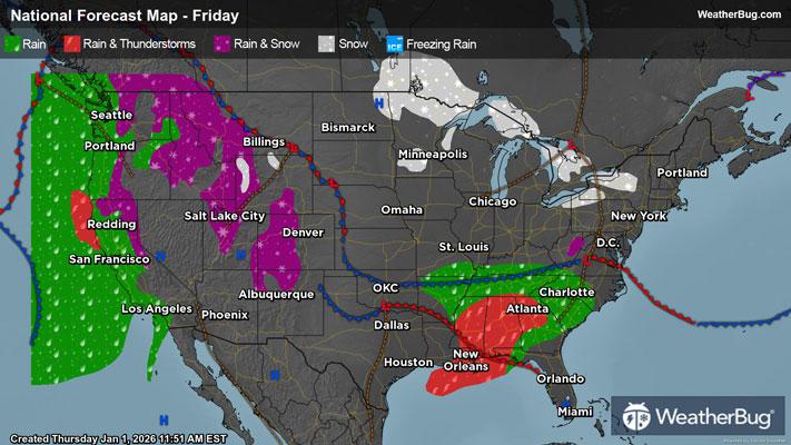
An upper-level low pressure system will move farther into California, while the surge of moisture drawn up ahead of the storm will spread across the Western U.S. through the rest of 2026's first day. Scattered light to moderate showers will be found across the lower elevations of California, the Northwest, Great Basin, and Four Corners states for the rest of today into Friday. Meanwhile, the middle and higher elevations see snow or a wintry mix of snow, rain and freezing rain.
This precipitation could slowly dissipate from west-to-east across the Western U.S. on Friday afternoon and evening. However, another surge of moisture will come barreling into the West by Friday night.
While downpours will be lighter than last week's pineapple express, soils are still rather saturated, leaving an increased threat of triggering flooding. The best chance will be across southern California, the Sierra Nevada range's western slopes, and coastal northern California. Burn scars, rivers, creeks, and streams as well as urban and low-lying areas will be prone to flooding. Those living in areas prone to flooding should also be prepared to take action should a flood develop.
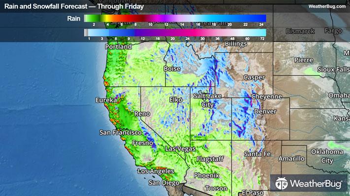
Through Friday, rainfall will reach 2.0 to 4.5 inches along both the Peninsular and Transverse Ranges, with 1 to 2 inches across their foothills as well as ahead of the Sierra Nevada Range and in coastal southern and central California. Rain less than an inch will rinse a vast majority of the Pacific Northwest, the Great Basin, the Desert Southwest, and the Mountain West.
Although a ridge of warm air over the Southwest will minimize middle and high-elevation snow before the weekend, snowpack additions of up to 16 inches will pile atop the peaks of the central Sierra Nevada Range, mainly today. Surprisingly, the fringe of a cold air mass remains over the Front Range, where peaks will observe up to 2 feet of snow accumulation! Snow amounts below a foot will fall across the Central Rockies’ ridges, the northern Cascades' peaks, and Front Range mid-elevations through Friday as the first moisture surge fizzles out.
Flood Watches are scattered across northern California as well as portions of southern California near Los Angeles. Winter Storm Watches/Warnings and Winter Weather Advisories are in effect for most of the Sierra Nevada Range and part of the Klamath Range. Additional Winter Weather Advisories are also posted across parts of southeastern and north-central Oregon, much of eastern Washington, northern Utah, northern Idaho, western Montana, western and south-central Wyoming, and western Colorado.
Following this first round's conclusion, another low pressure system approaching the Pacific Northwest will lasso another atmospheric river across the whole West Coast through this weekend. This time, heavy rain will focus on northern California and central California, including the Central Valley region.
Be sure to download the WeatherBug app to stay up to date on the latest on this changing weather. It’s never too early to have a supply kit packed in case of inclement weather. A simple kit including a weather radio, water, blankets, batteries, and non-perishable food items will go a long way in the event of a power outage.