Parade of Storms Hits The Plains, Midwest
The workweek will be filled with chances for severe thunderstorms in the middle of the country.
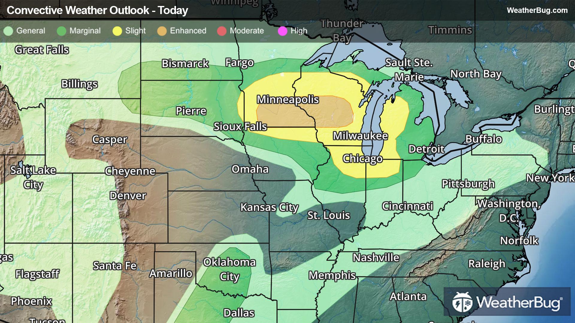
Most of today's severe weather will be focused on the Upper Midwest. The Storm Prediction Center has issued Slight and Enhanced Risks (levels 2 and 3 out of 5) across the southern half of Minnesota, northern Iowa, nearly all of Wisconsin, northern Illinois, northern Indiana and western portions of Michigan's Lower Peninsula. This includes Minneapolis, Chicago, and Milwaukee, Green Bay, and La Crosse, Wis.
Large hail will be the primary concern, along with gusty winds up to 60 mph. A few tornadoes are also possible.
Farther south, the dry line in the southern Plains could also kick off isolated thunderstorm activity this afternoon and evening. While the coverage will be spotty, any storms that form in central Oklahoma and central Texas from Oklahoma City southward into Wichita Falls and Abilene, Texas could produce large hail and gusty winds.
A series of low pressure systems will continue to march across the Central U.S. for the rest of the work week. This will lead to continued chances of severe weather across the Midwest and south-central U.S.
A Severe Thunderstorm Watch has been issued for northeastern Illinois, northern Indiana, and southwestern Michigan. Hail, gusty winds, and heavy bouts of rain are possible within these storms. Cities such as South Bend, Ind. are within this watch.
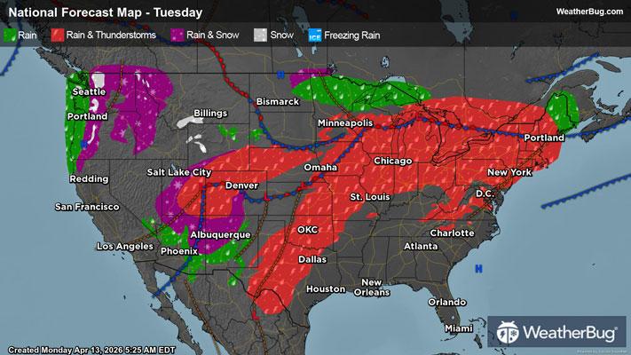
For Tuesday, there is a Slight Risk from central Texas northeastward across the middle Mississippi Valley and parts of the Midwest. There is even an Enhanced Risk from eastern Iowa into southern Wisconsin and northern Illinois. All modes of severe weather will be possible within the Slight and Enhanced Risks. Locally heavy rain up to 1 to 2 inches is also possible within these storms, which could lead to pockets of flash flooding.
Flood Watches are in effect across parts of northern Wisconsin, all of Michigan's Upper Peninsula, and northern portions of Michigan's Lower Peninsula from later today into Tuesday morning.
Make sure to know the difference between a watch and a warning should they be issued. A "watch" means that conditions are favorable for severe weather to occur, and to be on alert for any rapidly changing conditions. A "warning" means that severe weather is imminent, and you should act fast to remain safe.
The best way to remain safe is to stay prepared and informed about your local weather. Have a severe weather kit packed with a battery-operated radio, water, and non-perishable food items. Also, check the WeatherBug app frequently for any updates on today's severe weather. Remember, "When Thunder Roars, Go Indoors!"