
Weekend Weather Preview
An active springtime weather pattern is expected for large parts of the U.S. this weekend, with everything from wind-driven snow and blizzard-like conditions to heavy rain and dangerous thunderstorms expected.
Saturday
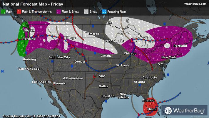
One low pressure system will dart across the Northeast into Atlantic Canada on Saturday. This will bring snow to western/northern New York and interior New England throughout the day. However, the best chance for snow will be in the morning and afternoon. Expect mainly light accumulations, if any. The exception will be northern/eastern Maine as well as areas immediately downwind from Lake Erie and Lake Ontario. These spots could see moderate to even briefly heavy snow at times.
A second low pressure will be forming over the Northwest and north-central U.S. to start the weekend. The best chance for precipitation will occur in the morning and afternoon for the Northwest and northern Rockies, while the northern Plains see the best chance of precipitation in the evening and overnight.
Coastal areas and lower elevations of the Northwest will be warm enough for precipitation to remain in the form of rain. Things are slightly more complicated for the mid and higher elevations of the Northwest, which will likely experience wet snow. There could even be some light freezing rain that leads to slippery conditions. Expect mainly snow for the northern Rockies and northern Plains, though some rain could mix in at times for the lowest elevations.
Winds will also be howling with this developing low pressure system. The strongest winds will be found in the central/southern Rockies into the High Plains. Here, wind gusts of 40 to 50 mph will be common. However, higher wind gusts up to 70 mph will be possible for the normal windy spots of Wyoming along I-25 and I-80. Anywhere that experiences both winds and snow should be prepared for blowing and drifting snow as well as reduced visibility. Downed trees and power lines could also be an issue, and there could be restrictions on light and high-profile vehicles traveling.
There will be a nearly stationary cold front draped over the Florida Peninsula. This will likely bring showers and perhaps a rumble or two of thunder. Otherwise, the rest of the Southern Tier will remain dry under high pressure.
The northern Rockies and Plains into the interior Northeast will experience the coldest temperatures on Saturday, with highs in the 20s and 30s. Though, a few spots right along the U.S.-Canada border could only see temperatures peak in the teens. Expect 20s and 30s as well for the tallest peaks in the Mountain West. Otherwise, 40s, 50s and lower 60s are in store for the rest of the Northern Tier. Sixties, 70s and 80s will be common throughout the Southern U.S., with the mercury soaring into the 90s across the Desert Southwest and west/southern Texas.
Sunday
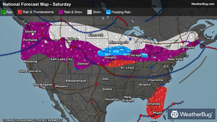
Saturday’s low pressure system that drifted across the northwestern and north-central U.S. will continue to strengthen as it advances eastward. By Sunday night, the low pressure will be centered over the Lower Midwest. There will also be an associated cold front that drops south across the nation’s midsection.
Like Saturday, there will be a wide range of impacts from this system. Precipitation will be found across the northern half of the Plains, the northern half of the Mississippi Valley and the Great Lakes throughout Sunday. The northern Plains, Upper Mississippi Valley and Upper Great Lakes will likely just see snow. Rain will be the predominant precipitation type across the central Plains and Mid-Mississippi Valley for much of the day, but some wet snow could mix in at times. This rain will transition over to all snow though in the evening. The Lower Great Lakes will pick up a wintry mix of snow, sleet and freezing rain in the morning, which will likely change over to rain in the afternoon. It should switch back over to this wintry mix late at night or early Monday morning.
Light to moderate snow will fall in the Rockies and Front Range in the morning along this cold front. Snow will taper off to flurries in the afternoon and will then end completely by Sunday evening.
Also associated with the cold front, rain and thunderstorms will be likely across the southern Plains into the Lower Mississippi and Tennessee valleys. Within this area, be prepared for torrential downpours and perhaps some strong to severe thunderstorms. Gusty winds, hail and perhaps a tornado or two will be possible in stronger storms.
In addition to gusty thunderstorms, non-thunderstorms winds could be an issue throughout the Central U.S. Impacts from strong winds will be the same as they were on Saturday – with blowing, drifting snow, lowered visibility, downed trees/power lines and travel restrictions all in play.
As if that wasn't enough, a warm front associated with the low pressure will lift across the Eastern U.S. for the conclusion of the weekend. There will generally be small chance of precipitation in the morning, with precipitation becoming increasingly likely during the afternoon and evening. Any precipitation in the Northeast will likely stay in the form of snow throughout much of the day, which could mix with and change over to rain late in the day. The rest of the Eastern Seaboard will experience rain showers and maybe a few isolated thunderstorms.
On the opposite side of the nation, there will be a surge of moisture into the Northwest. Following the theme for the rest of the U.S., there will be multiple precipitation types that occur. Lower elevations and coastal areas will just see rain, while middle elevations experience a mix of rain and snow. Wet snow will pile up in the mountains and higher elevations.
High pressure controls the weather across the rest of the West, fostering dry and quiet weather for the Great Basin, California and the Desert Southwest.
Temperatures in the Western and Eastern U.S. will follow a typical weather pattern, where the warmest temperatures occur in the afternoon. Expect 20s and 30s for the interior Northeast, while 40s and 50s cover the rest of the Northeast into the Mid-Atlantic. Sixties and 70s are forecast for the rest of the Eastern U.S.
Then, in the Western U.S., expect 20s and 30s for the Rockies and tallest peaks of the northern Cascades, with 40s and 50s for the rest of the Northwest into the Great Basin. Expect mainly 60s and 70s for the rest of the West, but 90s will occur once again in the Desert Southwest.
The Central U.S., however, will generally see their highest temperatures early in the day, with temperatures plummeting for the rest of the day thanks to a potent cold front. The northern Plains and Upper Mississippi Valley will record temperatures in the teens, 20s and 30s, which will plunge into single digits, teens and 20s by the afternoon and evening. The central Plains and Mid-Mississippi Valley will experience 40s, 50s and lower 60s early, which fall into the 20s, 30s and 40s later on. Parts of the southern Plains and Lower Mississippi Valley will record 70s and 80s around midday, which drop into the 50s and 60s. The exception will be far southern Texas that follows more of a typical weather pattern. Temperatures here peak in the 80s and 90s during the afternoon and a few isolated spots could see temperatures briefly exceed 100-degrees.