
Weekend Weather Preview
A potent weather system traverses the U.S. this weekend, bringing everything from accumulating snow and ice to rainy, stormy weather. Luckily, the weather quiets down for much of the nation in time for the Easter Bunny’s arrival.
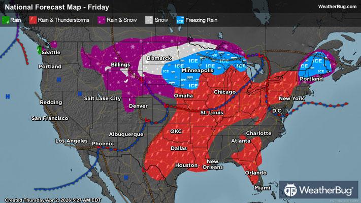
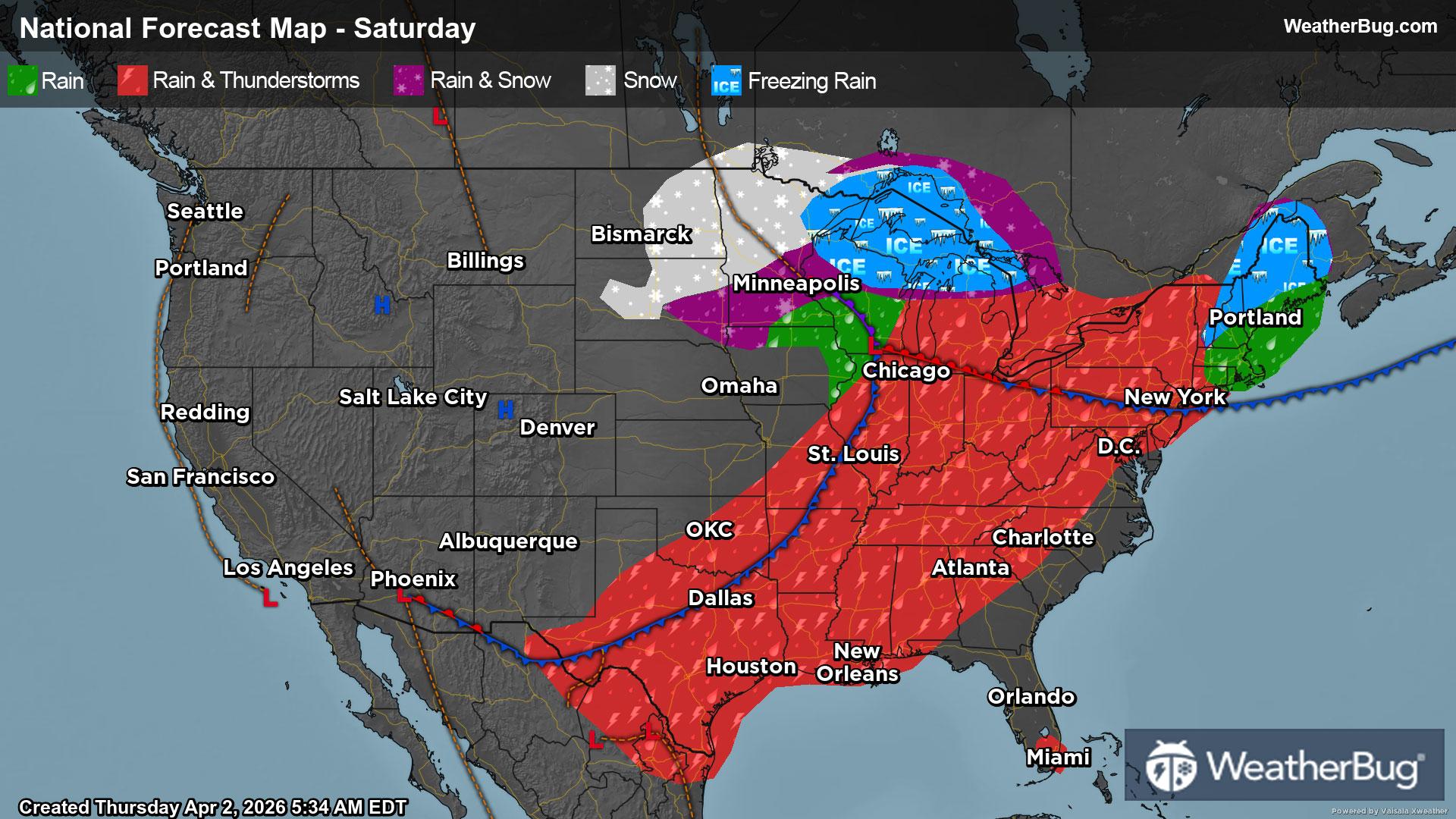
Saturday
Two low pressure systems will merge into one large, potent weather system on Saturday while drifting from the northern Plains into the Great Lakes and southeastern Canada. There will also be an associated cold front that is dragged through the nation’s midsection. A wide range of weather impacts are expected for the eastern two-thirds of the U.S. as a result.
On the northern and northwestern fringes of this system, temperatures will be cold enough for wintry precipitation. Snow will fall in the morning across the Dakotas and northern Minnesota, before tapering off and coming to an end in the afternoon and evening. Most spots will just see light snow intensity, but some locally moderate to heavy snow will be possible, mainly eastern North Dakota and the northern half of Minnesota.
Things get more complicated immediately south and east of this area of snow. Milder temperatures throughout the atmosphere will move over an area of cold, below freezing air close to the surface. This will translate into a considerable period of freezing rain across northern Wisconsin into Michigan’s Upper Peninsula. There could also be some sleet that mixes in at times. Freezing rain will likely transition over to plain rain by midday or early afternoon, then rain could mix with and change over to snow in the late evening and overnight.
Any area that sees wintry precipitation should be prepared for difficult, if not impossible, travel during the morning. Slick, slippery roads and reduced visibility will be likely. There could also be some downed trees and powerlines, leading to potential power outages.
Rain will soak the Lower Midwest and southern half of the Plains in the morning, then rain and thunderstorms will be likely during the afternoon and evening. Strong to severe thunderstorms will be a possibility, mainly for the Ohio and Lower Mississippi valleys. The main concern will be damaging winds, but some hail and maybe an isolated tornado cannot be ruled out.
Ahead of this merged low pressure system and cold front, some moisture will be funneled northward from the Gulf and Atlantic Ocean into the East Coast. Spotty showers and perhaps a few thunderstorms will be possible throughout the Southeast, Mid-Atlantic and southern New England, best chance in the afternoon and evening. A wintry mix of snow, freezing rain and rain could also spread to the interior Northeast late in the night.
At the same time, high pressure will build over the western third of the U.S. Expect dry and unseasonably warm weather for areas along and west of the Rockies.
Chilly 30s and 40s are expected for the taller elevations of the Rockies as well as the northern Plains, Upper Mississippi Valley, western portions of the Great Lakes and eastern New England. Though, a few isolated 20s are possible. Expect 50s and 60s for the Northwest, Great Basin and the rest of the Rockies into the central/southern Plains into the Mid-Mississippi Valley, eastern Great Lakes and the rest of New England. Milder 70s and 80s will be observed across California and Southwest into far southern Texas, the Deep South, Southeast and Mid-Atlantic. The typical hot spots of the Desert Southwest will have highs in the 90s.
Sunday (Easter)
The now-merged, expansive low pressure from Saturday will continue its trek eastward, with it moving it into Atlantic Canada by late Sunday. The associated cold front will push south and east of the Northeast and Mid-Atlantic by the afternoon or early evening, but it will continue to inch across the south-central U.S. and Southeast into early Monday morning.
Despite colder air filtering in behind the cold front, temperatures will generally be too mild for any wintry precipitation across the East, so any major concerns for Easter Day travel will be limited. Expect rain and perhaps some thunder from southern New England southward to Florida. Rain and thunderstorms will also be in the forecast for the Gulf Coast into southern Texas. While there could be some gusty winds, the system will lose its punch as it advances farther east, so severe weather will not be a major concern for outdoor Easter egg hunts.
The exception will be across the Upper Great Lakes and far northern New England, where temperatures will be cold enough for wintry precipitation. Expect mainly freezing rain across the northwest half of Maine and far northern New Hampshire during the morning, but some snow and sleet could also mix in at times. This will likely change over to plain rain during the afternoon and evening. Some wet snow or a rain/snow mix could also occur in the Upper Great Lakes throughout the day.
On the opposite side of the nation, high pressure will be in control of the weather for the western half of the U.S. Besides southern Texas, dry weather and mild to warm temperatures await most people in the Plains, Mountain West and West Coast. However, a few rain and mountain snow showers could occur in southeastern Arizona and southwestern New Mexico.
The coldest temperatures will be found in the far northern Plains, Upper Mississippi Valley, Upper Great and interior Northeast, where highs will be in the 30s and 40s. The tallest peaks in the Rockies, Cascades and Sierra Nevada could also see the mercury climb into the 40s. Fifties and lower 60s are expected for the rest of the Mountain West into the Lower Midwest and southern parts of the Northeast.
Sixties and 70s will be most common throughout the nation, including the Pacific Northwest, Great Basin and the central/southern Plains into the Tennessee Valley, Deep South and Mid-Atlantic. The Southeast will experience 80s, while 80s and 90s are in store for California and the Desert Southwest.