
Weekend Weather Preview
If April showers bring May flowers, this weekend will host those showers that prepare May for its floral array.
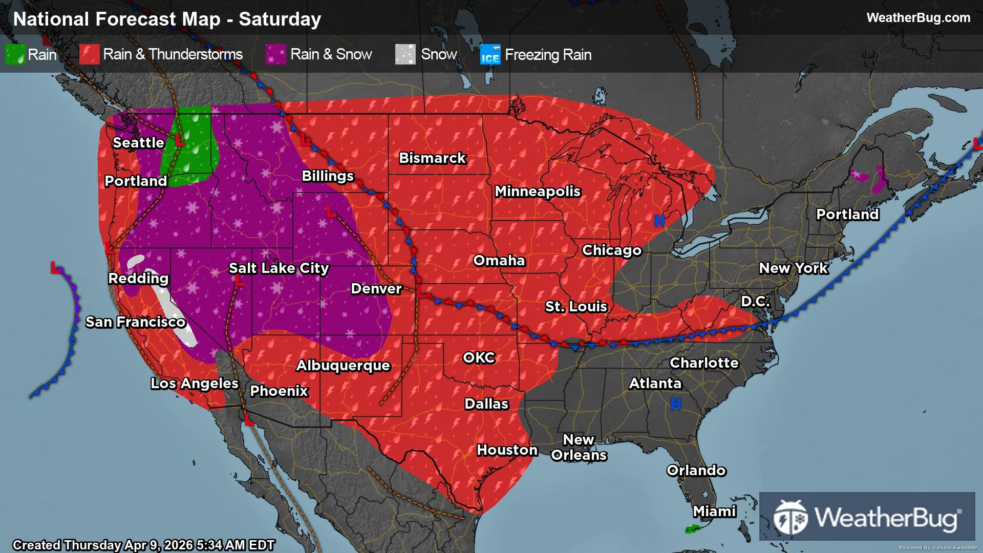
Saturday
In the Northeast, trailing moisture from a frontal system will bring rain showers to the region on Saturday, with the region drying out by Saturday evening. A rain and snow mix will stick to the Appalachians, bringing snow to the mountain tops in Maine.
The Mid-Atlantic should expect similar conditions, with light rain showers in the northern Mid-Atlantic that dry up by the evening hours. Some isolated thunderstorms are possible near the Appalachians, where the mountains will wring the clouds out, causing most of the precipitation to the east of the mountain peaks to be light.
The Southeast and Deep South should remain mostly dry on Saturday, with southern Florida and Texas receiving some rainfall with some isolated thunderstorms. A developing frontal system will be brewing over Texas, causing some heavy bouts of rain with the storms overhead.
The Midwest should expect the most stormy, rainy, and dreary weather this Saturday, with thunderstorms plundering the Plains, and moisture drifting into the Great Lakes region by the evening.
The Mountain West will be mountain-wet this Saturday, with a rain and snow mix expected over the Rockies. Rain will fall to lowland valleys, while there will be a dusting of snow accumulation on the higher mountainous peaks. Some isolated thunderstorms will also be possible in the southern Rockies throughout the day, with chances increasing in the northern Rockies by the evening.
The entire West Coast will be wet on Saturday, with rain showers extending from Washington state through southern California. There will be a rain and snow mix along the Cascades and Sierra Nevada, but populated areas should just see rain.
The nation is warming up this weekend overall, with areas remaining below-freezing being segregated to mountainous peaks along the Cascades, Rockies, and northern Appalachians in Maine. Forties are in store for the foothills of the Appalachians in the Northeast, lakeside regions of the northern Great Lakes, and the foothills of the Cascades.
Fifty-degree temperatures will be present in the remainder of the Northeast, Great Lakes, northern Plains, Great Basin Desert, and the coast of Washington through northern California. Areas with 60s in store for them on Saturday will be the northern Mid-Atlantic, Ohio River Valley, lowland areas of the Rockies, and the southern California coastline.
Areas expecting 70s this Saturday are Southeast Atlantic coastlines, central and southern Plains, and Desert Southwest.
The highest temperatures in the Continental U.S. this Saturday will be 80s in the Southeast and throughout the Rio Grande Valley in Texas.
Sunday
In the Northeast, dried out conditions from Saturday night will continue throughout the day as high pressure dominates out and head of a low pressure system. Wet weather won’t move into the area until late on Sunday night, where it will just be light rain.
Dry weather conditions will persist through the East Coast, keeping Sunday dry for the Mid-Atlantic and Southeast as well.
The Midwest, however, is not as fortunate and will experience a wet, rainy, and stormy Sunday. A low pressure system will continue to develop and strengthen over the Plains, bringing rain to the entire Midwest. This rain will be accompanied by stormy conditions that move eastward throughout the day. This line of thunderstorms has potential to produce storms that are severe in nature.
The Deep South will also experience wet, rainy, and stormy weather because of this system, bringing strong storms and heavy bouts of rain to Texas and moving eastward throughout Louisiana during the day. Severe storms are also possible in this region.
The Mountain West is not avoiding wet weather conditions this Sunday, as rain and snow will plague the region during the entirety of Sunday. Rain will fall to the valley floors, and snow will accumulate along the higher mountainous peaks in the Rockies.
West Coast wet weather conditions do not halt on Sunday, as continued conditions bring rain and snow from Washington down through southern California. As moisture moves through the area, rain will continue to fall in coastal regions and lowland areas, while snow will stick to the Cascades and Sierra Nevada.
Below-freezing temperatures will be limited to the mountainous peaks of the Rockies, Cascades, and Sierra Nevada this Sunday. Forties can be expected in the northern Northeast, northern Great Lakes, and foothills of the Rockies, Cascades, and Sierra Nevada.
Fifties will be present within the country among the Northeast, northern Great Lakes, lowland areas in the Rockies, and coastal regions of the West Coast from Washington through California. California’s central valley will also be in the 50s. Sixties, however, will be present within the northern Mid-Atlantic, northern Plains, and coastal southern California.
Seventies will be present within the Mid-Atlantic, southern Great Lakes, central and southern Plains, Texas, and the Desert Southwest. Areas seeing 80s will be the Ohio River Valley through the Southeast, extending down into the Rio Grande Valley.