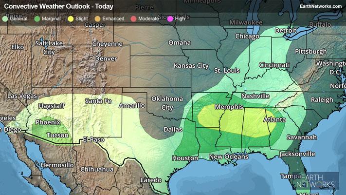
Flooding rains and severe storms will continue for the end of the week into the weekend.
The culprit for the active weather remains a nearly stalled frontal boundary that stretches from the southern Plains into the Ohio Valley and across the Mid-Atlantic. As waves of weather disturbances traverse this front, rounds of heavy rain and severe thunderstorms will continue over the next few days.
The Storm Prediction Center has issued a Slight Risk for severe thunderstorms stretching from central Texas into the Ohio Valley. Within this area, Enhanced Risk and Moderate Risk areas are found across northeastern Texas, southeastern Oklahoma, much of Arkansas, and southeastern Missouri.
Tornado Watches stretch from Texas to Tennessee, including most of Arkansas.
All forms of severe weather will be possible today into tonight, including damaging wind gusts in excess of 60 mph, golf ball-sized hail, and large and destructive tornadoes.
Saturday will see the focus of severe weather shift a bit to the south and east as the front finally becomes dislodged as a strong area of low pressure develops over the southern Plains and moves into the Tennessee Valley. A Slight Risk stretches from eastern Texas to northwestern Alabama to southwestern Ohio. An Enhanced Risk is also found across extreme eastern Texas, much of Louisiana, western Mississippi, southern and eastern Arkansas, and western Tennessee.
Once again, all modes of severe weather will be possible on Saturday, including a few large and destructive tornadoes.
In addition to the severe thunderstorms, rounds of moderate to heavy rainfall will occur each day and will result in localized flooding. Flood Watches remain in place from northeastern Texas and eastern Oklahoma northeastward into Ohio, western West Virginia, and southwestern Pennsylvania, where 3 to 6 inches of rain is expected over the next few days. Localized rain amounts of over 10 inches will be possible! Remember, if you approach a roadway covered in water, it is best to “Turn Around, Don’t Drown!”
Make sure to know the difference between a watch and a warning should they become issued. A watch means that conditions are favorable for severe weather to occur and to be on alert for any rapidly changing conditions. A warning means that severe weather is imminent, and you should act fast to remain safe.
The best way to remain safe is to stay prepared and informed about your local weather. Have a severe weather kit packed with a battery-operated radio, water, and non-perishable food items should you be without power for long periods of time. Also, check the WeatherBug app frequently for any updates on today’s severe weather. Remember, “When Thunder Roars, Go Indoors!”