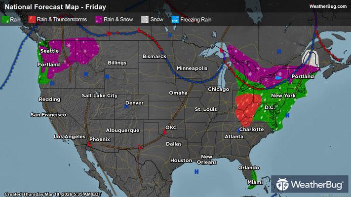
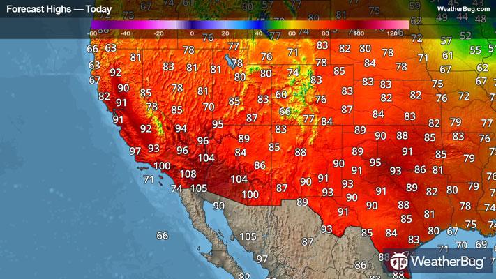
Dangerous Thunderstorms Impact Southeast U.S.
An organized system that brought severe weather to the Tennessee and Mississippi early this weekend will continue to impact the southeastern U.S. today.
A Severe Thunderstorm Watch has been issued across far northern Florida, southeastern Georgia, southern/coastal South Carolina, and eastern North Carolina. This includes Jacksonville, Fla., Savannah, Ga., Wilmington, N.C. and Charleston, S.C.
There’s been nearly 100 reports of wind damage and large hail from Kentucky to Gulf States on Saturday and Saturday night. While the severe threat will persist over the East Coast today, the number of damage reports should be lower.
A strong line of thunderstorms riding along a cold front will continue to bring the chance for a brief tornado and sporadic damaging winds in excess of 60 mph this morning and afternoon. By the time the squall line reaches central Florida late this afternoon, the severe threat should be significantly decreased.
The Storm Prediction Center currently has a Slight Risk for severe weather over northern Florida, southeastern Georgia, and eastern South Carolina. Cities included are Tallahassee and Jacksonville, Fla., Savannah, Ga. and Columbia, Charleston, and Hilton Head Island, S.c. A lower Marginal Risk for severe weather will be possible northward along the East Coast to Philadelphia today as well.
With the heaviest rainfall winding down, significant flooding will persist today for parts of the Tennessee and Ohio valleys in addition to central Appalachia. These areas picked up around 2 to 6 inches in the last 36 hours. Flood Watches and Warnings are ongoing from central Tennessee to southwestern Pennsylvania. A large number of streams and rivers are forecast to reach Moderate to Major flood stage if they haven’t already.
A large swath of Wind Advisories and High Wind Warnings cover the eastern U.S. today as well. Sustained winds may reach 20 to 30 mph in many areas, along with gusts 50 to 60 mph which will most likely occur during the afternoon hours.
Be sure to avoid flooded roadways as some of the rivers could remain in flood stage for the next few days. Find the latest watches and warnings on your local television, weather radio or WeatherBug.com.