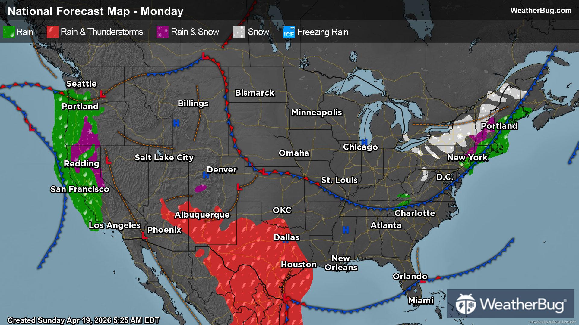
A slow-moving cold front will be the focus for showers and thunderstorms in the East, while California will see some April showers, and the Midsection charges sturdy storms this weekend.
Today
Showers and thunderstorms will be plentiful across the Northeast and Mid-Atlantic as a cold front bumbles eastward. Similarly, a fresh area of low pressure will start to develop across the central Plains, bringing rain as far north as the Dakotas and south into the ArkLaTex.
California and Oregon will be in line for an unusually late-season storm on Saturday as low pressure dives southward. Heavy rainfall will soak the coast and Central Valley, while snow is likely across the Sierra Nevada and far southern Cascades.
Otherwise, the Great Basin, Rockies, and Mississippi and Ohio valleys, and Southeast will enjoy generally dry weather.
Temperatures will only top out in the 50s across the Dakotas, Great Lakes, and northern New England, while widespread 60s will be found from the Pacific Northwest to the northern Rockies and from the Mid-Mississippi Valley to the upper Ohio Valley and southern New England. Much of California and Nevada will also see highs only in the 50s and 60s, with the mountains in the 40s and even 30s today.
A ribbon of 70s will stretch from northern Arizona to the Mid-South and northern Mid-Atlantic, with 80s commonplace from Arizona to Texas, and from Louisiana to Florida and even as far north as Washington, D.C. Early morning showers across the East Coast, and especially in New England, will make for a soggy first commute, but most showers will exit over the Atlantic Ocean by the late afternoon.
Sunday
The large upper-level weather system from today will be the catalyst for wet, stormy and even wintry weather across the western two-thirds of the nation on Sunday. This system will slowly push through the West Coast into the Rockies. Precipitation will be found throughout the storm system, but southerly winds ahead of it will also funnel moisture into the nation’s midsection.
The focus of precipitation will generally be found across the Northwest, northern and central California, the Great Basin and the northern Rockies throughout the day. Rain will soak most areas, while snow will fall at the tallest peaks of the Rockies. Rain will then spread to the northern High Plains.
Expect rain and thunderstorms throughout the central and southern Plains, most of the Mississippi Valley and Midwest for most of the day. However, the best chance will occur in the afternoon and evening. Within thunderstorms, there will be a chance of severe weather. Be on the lookout for torrential downpours, damaging winds, large hail and perhaps a tornado or two.
At the same time, low pressure will spin over the Northeast for the conclusion of the weekend. Rain showers will be in the forecast for most of the day, though the higher elevations of the Appalachians could see some wet snow or a rain/snow mix.
A few areas will see dry weather if you’re looking to be outdoors. This includes the Ohio Valley and Mid-Atlantic into the Southeast. The Desert Southwest and the central/southern Rockies should also be in the clear of any weather concerns.
The coldest spots on Sunday will be the interior Northeast as well as the higher elevations of the Mountain West. Here, temperatures will generally only peak in the 30s and 40s. Most of the West Coast into the lower elevations of the Mountain West will report temperatures in the 50s and 60s, though the interior Northwest will see highs in the 70s. Fifties and 60s will also occur in the Upper Mississippi Valley, Midwest, Great Lakes, Mid-Atlantic and southern parts of the Northeast.
Warmer 70s and 80s will occur throughout the Desert Southwest, most of the Plains, the Deep South and Southeast. The mercury will soar into the 90s for parts of western and southern Texas as well as most of Florida.