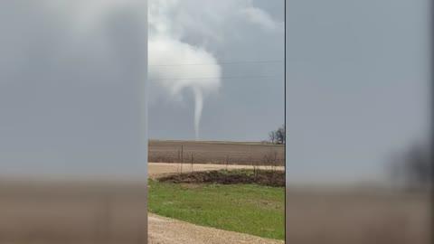
Cooler air brings relief to portions of the north-central to northeastern U.S.
A southward moving cold front continues its advance farther south out of the Great Lakes. The Midwest, Ohio Valley, and northern portions of the Northeast and Mid-Atlantic will begin to feel the difference in the humidity. Dewpoints in the 40s and 50s will set in, with temperatures solidly in the 70s.
During the morning, rain will exit the coastal sections of the Northeast, and northern Mid-Atlantic. Rain totals up to an inch are possible.
South of the cold front, the sticky temperatures and humidity will still be in place. Storms and showers will occupy the Mid-South, Mid-Atlantic, Southeast, southern Plains, and Gulf Coast. These may be gusty at times as well as loaded with the potential for scattered pockets of flash flooding. Some of these pockets could hold 2 to 3 inches at a time, especially in the Carolinas.
More storms will go boom in the High Plains and parts of the lower elevation Plains. These will have the potential for large hail and damaging winds.
The eastern and northern Rockies will be populated with scattered showers and storms. This activity will be maximized in Montana, Idaho, and eastern parts of Oregon and Washington. A few strong gusts can be expected as well as a couple instances of flash flooding.
It will be dry in most of the Great Basin, Desert Southwest, and along the Pacific Coast.
The highest terrain of the Rockies and northern Appalachians will see 50s for highs. Sixties will be found in northern sections of the Great Lakes and Northeast. Highs in the 70s are likely in the Northeast, Mid-Atlantic, Ohio Valley, Midwest, northern Plains, and along the Pacific Coast. The Pacific Northwest will see a mix of 70s, 80s, and 90s traveling from the coast to the interior states. Eighties will be seen in the Mid-South, Southeast, central Plains, and Great Basin. The Four Corners, southern Plains, and Gulf Coast will deal with hot 90s. Another day in the 100s will be in store for southern Texas and the Desert Southwest. A few 110s may be in store for the most extreme deserts in the Desert Southwest.