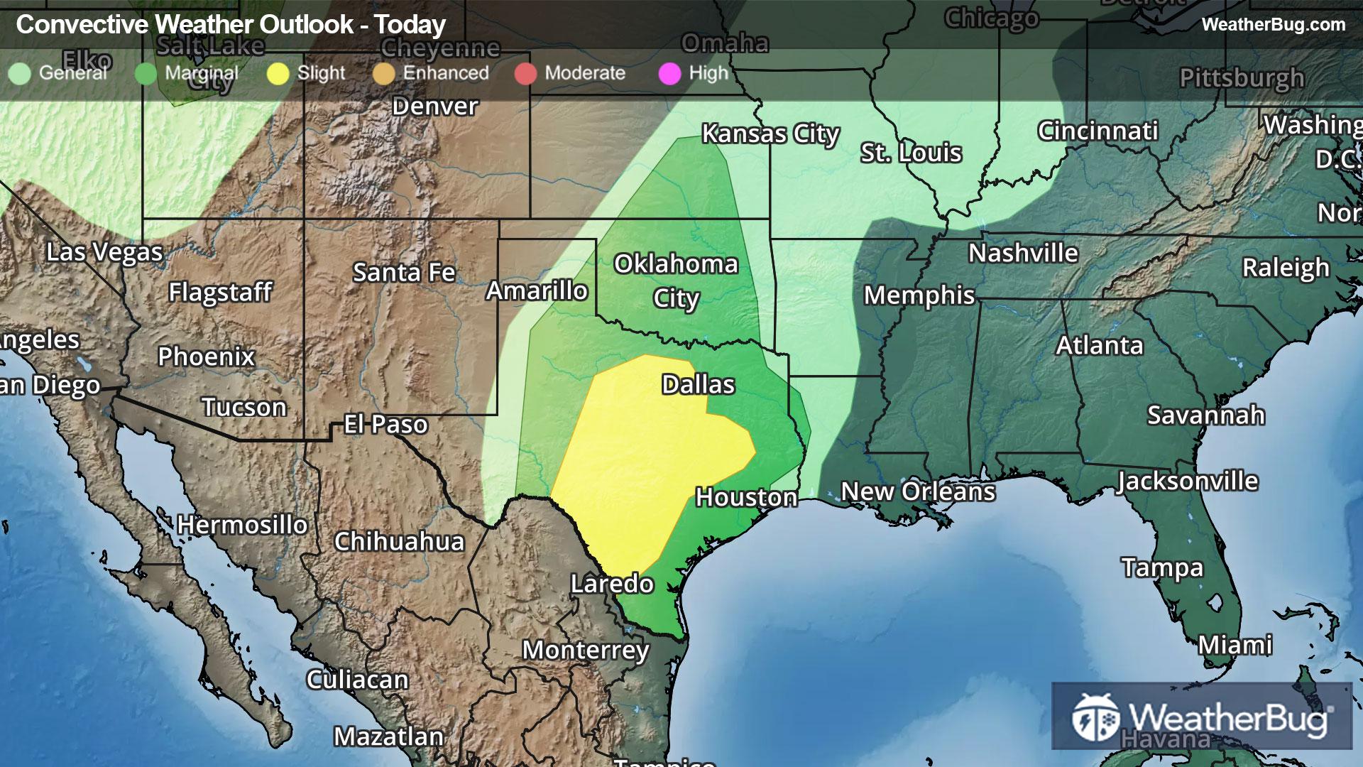
Hurricane Erin continues to churn up the waters off the Eastern Seaboard. Although the center will remain well offshore, the storm will come close enough to the shore to have some impacts, most notably across North Carolina and Virginia.
As of 2 p.m. EDT, Hurricane Erin was located near 35.6N and 70.5W, or about 285 miles east of Cape Hatteras, N.C., and about 400 miles northwest of Bermuda. Erin is packing top winds of 100 mph, making it a Category 2 hurricane on the Saffir-Simpson Hurricane Wind scale. It is moving northeast at 18 mph and has a minimum central pressure of 952 mb, or 28.12 inches of mercury.
A Tropical Storm Warning is in effect for the North Carolina Outer Banks and the southern half of the Delmarva Peninsula, specifically from Beaufort Inlet to Chincoteague, Va. This includes Pamlico and Albemarle sounds. A Tropical Storm Warning has been issued for Bermuda by the Bermuda Weather Service.
Erin will start to weaken by Friday as shear and cooler water slowly take their toll on the storm.
Erin’s wind swath is unusually large, with hurricane force winds extending 100 miles from the center and tropical storm force winds as much as 260 miles from the center. This is placing these strong winds just offshore of the Outer Banks, and will lead to this area being scraped by powerful winds through the rest of the day as the center remains well offshore.
By later today and Friday, Hurricane Erin will bend to the northeast, away from the U.S. East Coast. This will take the strongest impacts away from the shoreline, but the monstrous storm will continue to churn the western Atlantic waters well into the weekend.
The biggest threat from Hurricane Erin will be its storm surge and waves. A Storm Surge Warning is in effect for the Outer Banks from Cape Lookout to Duck, N.C. Here, surges of 2 to 4 feet are expected on top of any normal waves. This will likely push high tide levels onshore, placing North Carolina Route 12 – the backbone of the islands – underwater. Rip currents along the East Coast have closed beaches from the Carolinas to New England. Offshore, waves could be much higher, with potentially 10 to 20 foot waves peaking around 50 feet in the open ocean.
Heavy rainfall is possible on the Outer Banks of North Carolina today. There will be the potential for rainfall amounts of 1 to 2 inches, with locally higher amounts up to 4 inches. In addition, tropical storm-force winds (winds of 39 to 73 mph) are possible over parts of the North Carolina Outer Banks throughout today. These tropical storm-force winds will be possible in Bermuda as well.
Although Erin will not make landfall and will be a memory by the end of the weekend, it is a signal that the peak of hurricane season has arrived. If you haven’t already, now is the time to prepare for the hurricane season. Have a “go” bag ready with chargers, water, food and other necessities. Also, take the time to scope out multiple evacuation routes, in case your preferred one is traffic-jammed or blocked.
Erin is the fifth named storm of the 2025 Atlantic hurricane season and the first hurricane and major hurricane. It briefly achieved Category 5 status on Saturday morning, with peak sustained winds of 160 mph. The 2025 Atlantic hurricane season is now the fourth straight season to feature a Category 5 storm, with two occurring last year — hurricanes Beryl and Milton.