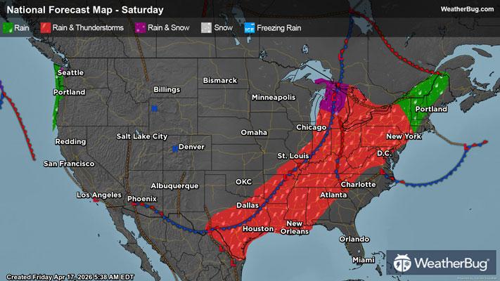
Severe Thunderstorms Take Aim at the Plains, Midwest
Widespread severe thunderstorms, including very large hail and tornadoes, are likely across the Plains to the Midwest today.
Read More
# HEADLINE -------------------- FLOOD WATCH IN EFFECT THROUGH LATE TONIGHT # DETAILS -------------------- WHAT Flooding caused by excessive rainfall continues to be possible. WHERE Portions of Illinois, including the following areas, Adams IL, Brown IL, Calhoun IL, Greene IL, Jersey IL, Macoupin IL, Montgomery IL and Pike IL and Missouri, including the following areas, Audrain MO, Knox MO, Lewis MO, Lincoln MO, Marion MO, Monroe MO, Montgomery MO, Pike MO, Ralls MO and Shelby MO. WHEN Through late tonight. IMPACTS Excessive runoff may result in flooding of rivers, creeks, streams, and other low-lying and flood-prone locations. Storm drains and ditches may become clogged with debris. ADDITIONAL DETAILS - Rainfall amounts of up to 3 inches may fall in this area and cause localized flooding. ISSUED AT Friday, April 17, 2026 at 1:11 PM CDT ISSUED BY National Weather Service St Louis MO HEADER URGENT - IMMEDIATE BROADCAST REQUESTED | Flood Watch # PRECAUTIONARY/PREPAREDNESS ACTIONS -------------------- You should monitor later forecasts and be alert for possible Flood Warnings. Those living in areas prone to flooding should be prepared to take action should flooding develop. # AREAS AFFECTED -------------------- Calhoun IL, Adams IL, Audrain MO, Brown IL, Greene IL, Jersey IL, Knox MO, Lewis MO, Lincoln MO, Macoupin IL, Marion MO, Monroe MO, Montgomery IL, Montgomery MO, Pike IL, Pike MO, Ralls MO, Shelby MO Including the cities of Quincy, Mexico, Litchfield, Pittsfield, Mount Sterling, Bowling Green, and Hannibal
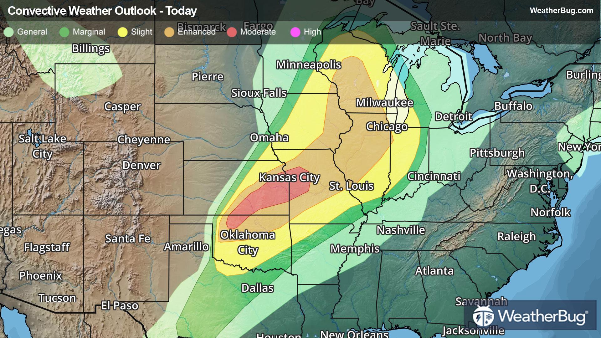
There is a Enhanced Severe Storm Risk for your location. Continue reading for today's outlook from the National Weather Service's Storm Prediction Center. -------------------- National Severe Storm Outlook THERE IS AN ENHANCED RISK OF SEVERE THUNDERSTORMS OVER MUCH OF ILLINOIS INTO NORTHEAST MISSOURI...AND OVER NORTHERN OKLAHOMA SUMMARY Damaging storms producing wind, hail and isolated tornadoes remain possible this evening from Illinois into Oklahoma. WI/MI into IL and MO Supercells have largely merged into a broken line of assorted bows from far southeast WI across much of northern into western IL and trailing into northeast MO. The 00Z ILX sounding shows steep lapse rates aloft and large deep-layer shear, as well as veering winds with height. Low-level SRH will remain favorable for rotation to develop at least briefly anywhere within the line, with damaging winds the most likely threat. Storms have recently become better organized over central MO, and this activity may affect the St. Louis area later tonight. For lower MI into northern IN, the organized line of storms to the west along with a 60 kt low-level jet suggest at least isolated severe gusts may occur overnight despite lesser instability. For more information about Illinois, see mesoscale discussion 484. OK...Southeast KS...southwest MO...northwest AR Scattered severe cells persist near and north of the cold front across much of northern OK and extending into southeast KS. Although the undercutting cold air will likely mitigate wind potential, steep lapse rates aloft along with ample deep-layer shear will continue to favor hail. Storm coverage may be more isolated into southwest OK later tonight, but the environment remains quite favorable for large hail. One corridor for possible damaging wind or even a tornado is over northeast OK into southwest MO. Here, the front is not surging as fast, and storms over Osage county are already oriented more favorably N-S relative to the deep-layer shear. A southwest low-level jet near 50 kt will further support low-level rotation.
Pollen Index: 10.9 Pollen Level: high Predominant Pollen: Poplar/Aspen/Cottonwood, Cedar/Juniper and Elm. Concentration of pollen grains in the air for Saturday will be falling in the moderate range. This change results in part from falling temperatures and heavy rains in the morning and evening which tend to wash pollen out of the air. That's good news for allergy sufferers.