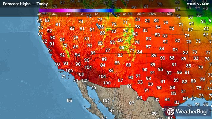
URGENT - WINTER WEATHER MESSAGE
National Weather Service Baltimore MD/Washington DC
938 AM EST Sat Dec 13 2025
District of Columbia-Cecil-Southern Baltimore-Prince Georges-Anne Arundel-Northwest Montgomery-Central and Southeast Montgomery- Northwest Howard-Central and Southeast Howard-Southeast Harford- Fairfax-Arlington/Falls Church/Alexandria- 938 AM EST Sat Dec 13 2025
...WINTER WEATHER ADVISORY NOW IN EFFECT FROM MIDNIGHT TONIGHT TO 10 AM EST SUNDAY...
* WHAT...Snow expected. Total snow accumulations between 1 and 3 inches. Localized totals of 4 to 5 inches across portions of Harford and Cecil counties.
* WHERE...Portions of DC, central, northeast, and northern Maryland, and northern Virginia.
* WHEN...From midnight tonight to 10 AM EST Sunday.
* IMPACTS...Plan on slippery road conditions.
* ADDITIONAL DETAILS...Precipitation may briefly start as rain in some locations but quickly turn to snow. A narrow band of heavier snow may develop between 1 and 5 AM which could produce more rapid accumulations and visibility less than one half mile.
PRECAUTIONARY/PREPAREDNESS ACTIONS...
Slow down and use caution while traveling. The latest road conditions for the state you are calling from can be obtained by calling 5 1 1.
&&