Back to forecast
Big Storms Threaten Lower Mississippi Valley, Deep South Today
January 5, 2025 at 11:38 PM EST
Updated By WeatherBug Meteorologist, Fred Allen

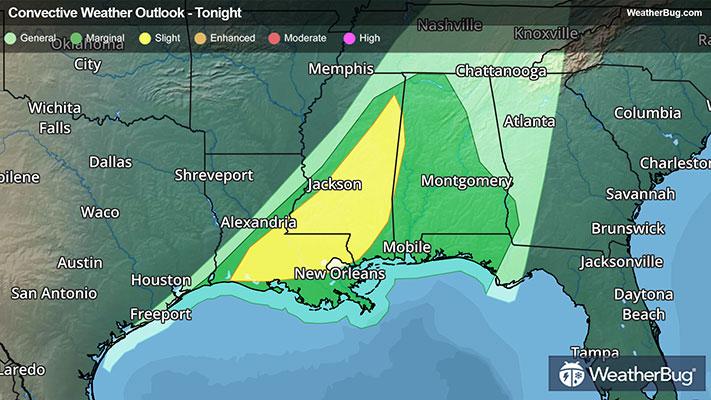
Robust thunderstorms will rumble across the Lower Mississippi Valley and Deep South this afternoon and evening. Damaging wind gusts, a few tornadoes, including one or two that are intense, and hail will be on the weather menu.
A cold front separating warm, humid air ahead of it from significantly colder, much drier air in its wake is teaming up to foster a lengthy line of dangerous thunderstorms from Mississippi to southeastern Texas. This line will rummage eastward, eventually losing its punch across northern Georgia, Alabama, and the Florida Panhandle tonight.
Tornado Watches remain in effect for portions of eastern Mississippi including Hattiesburg and Meridian, Miss.
An Enhanced Risk for fast-moving, organized severe storm outbreak from northeastern Louisiana into far southeastern Arkansas and west-central Mississippi has been maintained by the government’s Storm Prediction Center this afternoon and evening. Cities in this danger zone include Monroe and Alexandria, La., as well as Jackson, Greenville, and Vicksburg, Miss.
The primary risks remain isolated damaging wind gusts up to 75 mph and a few tornadoes, which one or two could be intense. Isolated large hail exceeding quarter size will be possible as well.
Memphis, Tenn., southwestern suburbs, and Lake Charles and Shreveport to Lafayette, La., will need to keep a watchful eye on the sky for threatening weather. Even Tuscaloosa, Birmingham, and Mobile, Ala., may have a dangerous storm encounter before the severe weather risk finally wraps up early on Monday morning.
So far today, a couple handfuls of severe weather reports have been observed from Texas to Arkansas and Louisiana. In Avery, Ark., a possible tornado was captured on video by a local firefighter. Additional thunderstorms this afternoon have produced tree and powerline damage in Texas and Louisiana.
The best way to remain safe is to stay prepared and informed about your local weather. Have a severe weather kit packed with a battery-operated radio, water and non-perishable food items should you be without power for long periods of time. Also, check the WeatherBug app frequently for any updates on today's severe weather. Remember, “When Thunder Roars, Go Indoors!”